1/9


Trainsity Kuala Lumpur LRT KTM
1K+ดาวน์โหลด
11.5MBขนาด
2.10.0(15-01-2025)เวอร์ชั่นล่าสุด
รายละเอียดรีวิวเวอร์ชั่นข้อมูล
1/9
คำอธิบายของTrainsity Kuala Lumpur LRT KTM
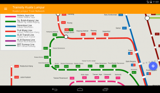
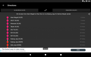
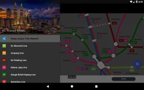
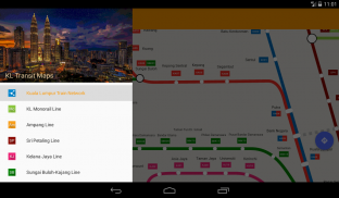
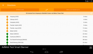
ค้นหาเส้นทางของคุณรอบเมืองกัวลาลัมเปอร์โดยใช้แผนที่เวกเตอร์ความละเอียดสูงของสาย KTM Komuter, สาย RapidKL และสายเชื่อมโยงรถไฟด่วน KLIA รวมถึงสาย BRT Sunway แผนที่มีขนาดไฟล์เล็ก แต่มีระดับการซูมหลายระดับและสามารถทำงานออฟไลน์ได้โดยไม่ต้องเชื่อมต่ออินเทอร์เน็ต ผู้ใช้สามารถคลิกที่ป้ายสถานีรถไฟเพื่อเปิด Google แผนที่หรือสตรีทวิวที่ซึ่งพวกเขาสามารถใช้ฟังก์ชั่นทั้งหมดของแอพ Google เพื่อแสดงภาพพื้นที่โดยรอบและ / หรือทำการกำหนดเส้นทางสำหรับเส้นทาง นอกจากนี้ยังมีฟังก์ชั่นออฟไลน์เพื่อคำนวณวิธีที่ดีที่สุดในการเดินทางจากสถานีหนึ่งไปยังอีกสถานีหนึ่งที่มีการแบ่งทิศทางและการกำหนดเวลา (ซึ่งอาจแตกต่างจากเวลาเดินทางจริง)
* ขณะนี้มีโหมดมืด
Trainsity Kuala Lumpur LRT KTM--เวอร์ชั่น2.10.0
(15-01-2025)ข่าวใหม่Add missing Pudu station.Remodel transit network graph.
รับประกันแอปดี!แอปนี้ผ่านการทดสอบความปลอดภัยด้านไวรัส มัลแวร์ และสิ่งโจมตีอื่นๆ
และไม่มีสิ่งคุกคามใดๆ
Trainsity Kuala Lumpur LRT KTM - ข้อมูล APK
เวอร์ชั่น APK: 2.10.0แพ็คเกจ: com.dom925.trainsity.kualalumpurชื่อ: Trainsity Kuala Lumpur LRT KTMขนาด: 11.5 MBดาวน์โหลด: 1เวอร์ชั่น : 2.10.0วันที่ปล่อย: 2025-01-15 14:02:04หน้าจอขั้นต่ำ: SMALLCPU ที่รองรับ:
ID ของแพคเกจ: com.dom925.trainsity.kualalumpurลายเซ็น SHA1: E5:9D:19:FD:8D:A4:3A:AF:CD:14:FF:7A:C8:C2:21:93:15:E5:49:67นักพัฒนา (CN): Dominic Chinองค์กร (O): ท้องถิ่น (L): ประเทศ (C): SGรัฐ/เมือง (ST): ID ของแพคเกจ: com.dom925.trainsity.kualalumpurลายเซ็น SHA1: E5:9D:19:FD:8D:A4:3A:AF:CD:14:FF:7A:C8:C2:21:93:15:E5:49:67นักพัฒนา (CN): Dominic Chinองค์กร (O): ท้องถิ่น (L): ประเทศ (C): SGรัฐ/เมือง (ST):
เวอร์ชั่นล่าสุดของTrainsity Kuala Lumpur LRT KTM
2.10.0
15/1/20251 ดาวน์โหลด11 MB ขนาด
เวอร์ชั่นอื่น
2.9.310
6/8/20241 ดาวน์โหลด8 MB ขนาด
2.9.305
2/8/20241 ดาวน์โหลด8 MB ขนาด
2.7.200
22/11/20231 ดาวน์โหลด4 MB ขนาด
2.6.100
8/6/20231 ดาวน์โหลด4 MB ขนาด
2.5.100
25/3/20231 ดาวน์โหลด4 MB ขนาด
2.4.100
28/6/20221 ดาวน์โหลด4 MB ขนาด
2.2.95
14/8/20201 ดาวน์โหลด3 MB ขนาด
2.2.88
20/5/20201 ดาวน์โหลด3 MB ขนาด


Age of Apes 3.55
3.55
3.55


แอปในประเภทเดียวกัน

คุณอาจจะชอบ...

English


